
Aireville Park is a large open space, with many trees bushes and a path circulating the park, situated on the outskirts of Skipton that includes many facilities including a 14 hole pitch and putt course, a skatepark, pump track for bikes, a children's play area and a multi-use games area offering netball, football and tennis. It is located next to the Craven Fitness Center and Swimming Pool and in close proximity is Skipton Academy, Craven College, Skipton Girls' High School and Ermysteds Grammar School.
There is plenty of transport to and from the park as there is a car park next to the park with three hours free parking, the train station is a ten minute walk away and the bus station is a 15 minute walk away as well as there being pavements and paths for bikes and pedestrians; these paths are also useful for our disabled users and guide the circulation of the park.
In the area there are some listed buildings, however, these are too far away to be affected by the new building. Also, the park is on a slight hill so I will need to factor that into my design of the building.
Site Survey
Laing O'Rourke came over and met us at the site before setting up the theodolite whilst the rest of us drew a picture/map of the park and took photos as well. Then we stuck some metal pegs in the ground before placing the prism detail pole ontop whilst someone else looked through the theodolite and pressed a button on it to set the coordinates for the square. A theodolite is the piece of equipment that site surveyors use; it is a rotating telescope for measuring horizontal and vertical angles. Afterwards, one group walked the perimeter stopping at regular intervals where there was a rise or dip in the land. Each time they stopped they would place the prism detail pole in the ground making sure that the circle was inside the other circle and that they could see the group that were looking through the theodolite at all times. Once all 50 points of the perimeter had been set the groups swapped over so that the other group could walk around with the prism detail pole but were plotting the points of the trees and the other group could use the theodolite. Once each point had been plotted we wrote the number of the point on our picture/map that we had drawn at the start. These coordinates will help is see the size of the land, the shape, where the trees and paths are etc in Revit so that I can plan my building on the correct scale, factoring in the land.
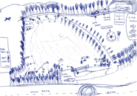
This is my rough sketch of Aireville Park
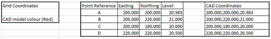
These are the co-ordinates of the grid for the site surveying.
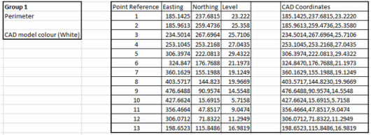
These are the co-ordinates for the perimeter of Aireville Park.
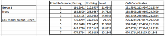
These are the co-ordinates of the positions of the trees in Aireville Park.
